UPDATE
This article was written while the subject events were under debate. Later, the Tank Museum accepted the proposed revision to the story.
Where was tiger 131 captured?
Dale Oscroft’s research into the capture of Tiger 131 has unearthed documentary evidence that it happened at "Point 174" on 24th April 1943. The Tank Museum’s account of the event puts it at Djebel Djaffa on 21st April 1943. These two hills are fifteen kilometres apart; tank battles occurred at both places but they cannot be spoken of as a single event. Therefore the Tank Museum's account is contradicted by the documentary evidence.
In this article, I seek a "second opinion" by examining the photographic evidence. For the sake of independence I give equal consideration to both locations. I use the battle reports only to determine where the German tanks operated.
The photographs
More than 25 photographs of this Tiger were taken in Tunisia after its capture; there is also a newsreel clip. They show the tank in several locations. There is usually no accompanying text.
Determining where a photo was taken
A tool called "Google Earth" allows one to view the horizon from any point and examine the shape of the landscape. It simulates terrain using cartographic maps and satellite imagery. If a wartime photograph shows distinctive hilltops, or large geological features, one can seek them in the terrain model.
Limitations of google earth
The terrain model has a resolution of several meters; therefore small features such as ravines are not rendered correctly, and the ground in general is slightly misshapen. But large features such as hills are accurately shaped. Satellite imagery is painted onto the surface of the terrain model. These images date from some 80 years after the photographs that we are investigating; therefore we must allow for changes to the landscape, such as additional buildings and roads.
The two proposed locations

This is an overall view of Djebel Jaffa. The battle report suggests that the Tiger would be found on the north side of the hill, but I will consider the entire area where German tanks operated during the battle. This area is marked in red here.
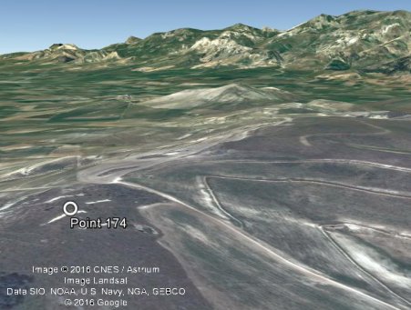
This is an overall view of "Point 174", whose real name is Gueriat el Atach. The battle report states that Tigers were located some 300 yards from the summit, on the eastern side of the hill. The road in the lower right of the image runs through there. I will consider that whole area.
Candidate photographs
I will restrict the search to places resembling the candidate locations. Most photographs of Tiger 131 in Tunisia can be immediately ruled out. They show the tank in a vehicle park, or on a plain, or under test.
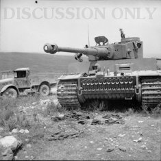
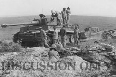
These two photos were taken at a single location; besides the obvious similarities in the background, there is a weed under the Tiger's left track in both photos. A road or track is behind the tank, glimpsed in one photo but also evidenced by the traffic.
There is also a newsreel clip showing Tiger 131. The camera is on high ground; it pans around and finishes with a view of the tank. It is obviously not in the same spot as shown by the pair of photos, therefore this is a second candidate location.
I know of no other photographs of Tiger 131 that show enough background for this investigation.
The first location
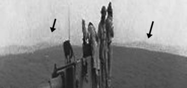
At the first candidate location, the angle of the sunlight tells us that we are looking approximately North. Enhancement of the photo, including vertical stretching, shows that the hill has larger hills beyond it, indicated here.
When seeking a similar place at Djebel Jaffa, we immediately run into a serious problem. The hillside in the photo has a smooth texture and is probably a crop; but all of the hills near to Djebel Jaffa are now covered by scrub.

An exhaustive search of the area yields only a single hill that can match the photo. In that case, Tiger 131 would be on the north side of Djebel Jaffa, which is consistent with the battle reports. Using Google Earth to seek a view of the terrain that resembles the photo, we find a good match at 36°33'30.32"N 9°36'32.10"E. Here is the view from that point, which I have stretched for clarity; there are hills just beyond the nearest hill. They don't match up exactly in shape with the photo, but that is typical of Google Earth when small features are rendered.
But this location has a second problem. The photo shows a road or track with a pale surface, typical of minor roads in Tunisia at the time; the satellite imagery shows only a trail, the same colour as the terrain.

On the east side of Point 174, standing at 36°40'6.91"N 9°43'55.06"E we can see a range of distant hills beyond a nearby hill. The nearby hill (coloured dark in this image) does not curve in quite the same way as the one in the photo, but that is typical of Google Earth when small features are rendered. We would expect the large hills, which are 15km away, to be a much better match.

This combined image compares the hills in the 1943 photo to the hills rendered by Google Earth (stretched vertically for clarity). The peaks match up.
So, in conclusion; these two photos show Tiger 131 at a place that is a problematic and unsatisfactory match to Djebel Jaffa, but a good match to Point 174.
The second location

The newsreel camera panned around at the second location, and from that we can create this "panorama" image. It shows a nearby hill and a distant line of larger hills faded by the haze. Tiger 131 is at the right.
Through enhancement of the image we can make the distant hills more visible. They match well to the horizon rendered by Google Earth from Point 174, but only if you are near the summit.
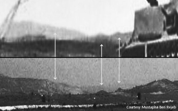
A photo taken at the second location shows Tiger 131 and a glimpse of the horizon behind it. This is very convincing evidence that the tank is on Point 174 because a modern photo taken from the summit shows a matching horizon.
At Djebel Jaffa the view to the north is blocked. From certain places it is possible to see the distant line of hills from the panorama image, but those places are not where the tanks fought. None of the other details can be matched.
So, in conclusion; the newsreel and the photo match up very well to the view from the summit of Point 174. They cannot be reproduced near Djebel Jaffa.
Conclusion
Tiger 131 was photographed at two places on Point 174. One of the places corresponds to the battle report, which states that Tigers fired on British forces from some distance downhill. The other place is the summit of the hill, where British troops held positions during the battle and for several days afterwards.